Land eligibility for RE ¶
The subject of this chapter is the analysis of land eligibility for wind energy and photovoltaics.
We identified several issues in workshops with local stakeholders, which we will address in this chapter. First, the land use - especially for wind energy - became a key matter of debate in Germany and, to the same extend, in the ABW region as the number of wind turbines have been growing dramatically during the last decades. On the one hand, renewables are perceived as a key element of the energy transition. Superordinate targets set by the federal government have to be implemented on a local level. On the other hand, regional concerns should be considered as the designation of wind turbine sites by regional planning authorities and their realization crucially depend on the acceptance of the people living in the surroundings of those sites. This matter of conflict motivates the question: “To what extent can the region be supplied by renewables considering the available area?”
Wind energy ¶
Wind energy makes the largest contribution to renewable power generation in the ABW region. In the end of 2017, 438 turbines with an installed capacity of 717 megawatts already covered around 45% of the regional electricity demand. The further expansion and repowering of existing plants plays an important role in the transformation of the energy system in the region according to the climate and energy concept of the state of Saxony-Anhalt [77] .
Wind turbines are privileged according to §35 BauGB. However, it is necessary to consider important concerns such as nature and resident protection as well as the control of wind energy planning by designating so-called concentration areas in regional and land use plans with preclusive effects in the remaining planning area [78] . In the ABW region, it is the responsibility of the regional planning authority ( Regionale Planungsgemeinschaft Anhalt-Bitterfed-Wittenberg ) to designate such priority areas (VR/EG, German: Vorrang-/Eignungsgebiete), the Teilplan Wind ABW (2018) can be found in [79] . The planning area includes the districts of Wittenberg, Anhalt-Bitterfeld and the independent city of Dessau-Roßlau [80] .
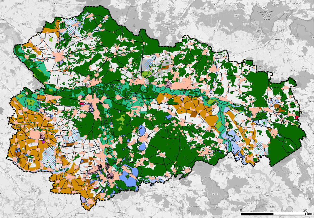
In a nutshell, so-called “strict” and “weak” restriction areas are excluded from the planning area, which are not available for wind energy use for various reasons (e.g. nature conservation, existing infrastructure, other interests, etc.). This results in potentially eligible areas - the so-called “search area” - which account for around 10% of the entire planning area. These areas are subject to a case-by-case examination, which leads to an exclusion of about 90% of the search area. As a result, approx. 1 % of the planning area is still available for the designation of VR/EG as shown in Fig. 5 ; 3590 ha (0.98 %) were actually designated as VR/EG [79] .
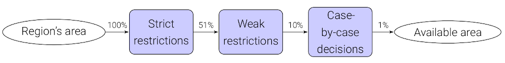
Fig. 5 Calculation of eligible areas for wind turbines ¶
The individual steps are described in the following subsections.
Restriction areas ¶
Regulations and assumptions on the restriction areas are taken from [79] , [81] , [82] as well as the current legislation in force. The restriction areas include:
- “Strict” restrictions
-
-
Settlements (+500 m buffer)
-
Existing infrastructure such as roads, railway tracks, airfields
-
Nature conservation areas
-
Protected landscape elements (German: Geschützte Landschaftsbestandteile)
-
Special protection areas (SPA)
-
Drinking water protection areas: zones I+II
-
- “Weak” restrictions
-
-
1000 m buffer zone around settlements
-
Fauna flora habitats
-
Forest defined in § 2 WaldG LSA
-
UNESCO heritage sites (in ABW: Gartenreich Dessau-Wörlitz )
-
Floodplains
-
Standing water bodies >1 ha (+65 m buffer)
-
Rivers of 1st order (+65 m buffer)
-
Results ¶
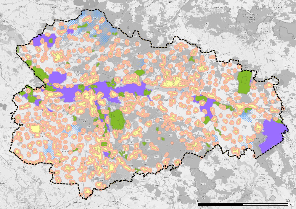
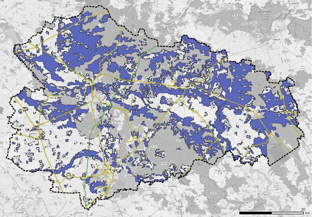
Merging all strict and weak restrictions gives the total restrictive area shown in black in Fig. 6 . All other areas represent the eligible space for wind turbines (~10 %). For comparison, the designated wind priority areas VR/EG (data from Teilplan Wind ABW (2018) [79] ) are plotted in green (3590 ha in total which equals 0.98 % of the region’s area).
Fig. 6 Merged restriction areas (black) and designated wind priority areas VR/EG (green) ¶
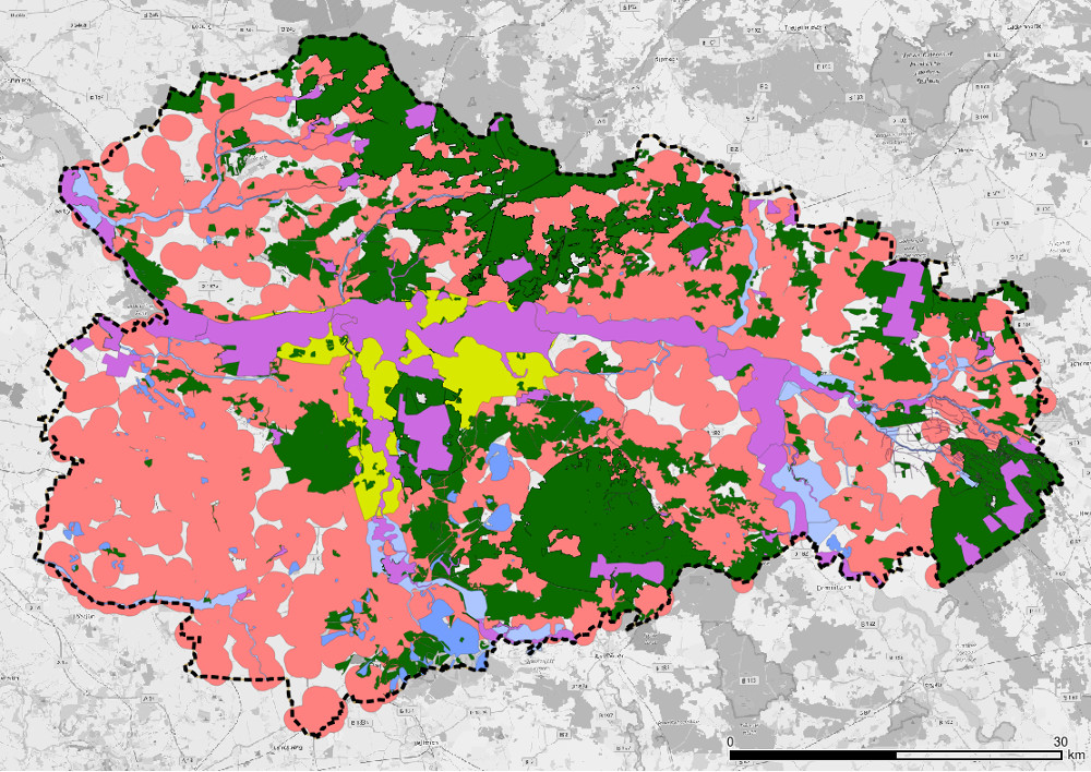
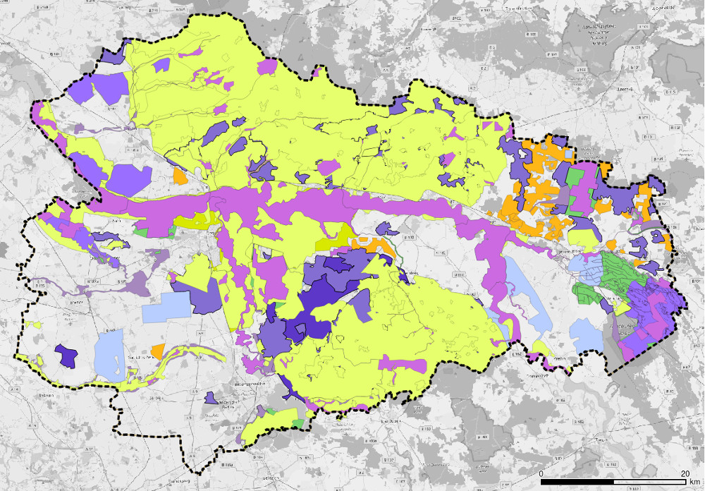
Fig. 7 shows an example of the resulting potential areas with a distance to settlements of 500 m and use of forests:
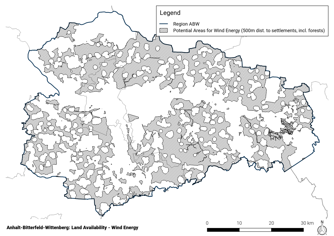
Fig. 7 Potential areas with distance to settlements of 500 m and use of forests ¶
Other restrictions not covered by geodata: case-by-case examination ¶
While the previous restrictions can be modelled using geodata, the final step of case-by-case examination cannot. Therefore, a reduction of the total potential area is estimated for the case-by-case examination using the numbers on designated wind priority areas of today from Teilplan Wind ABW (2018) [79] : reduction factor = Area(wind priority areas) / Area(potential areas) = 10 %. This across-the-board reduction factor is applied to the potential areas for all scenarios to calculate the eligible space.
The areas subject to individual examination include
-
Buffer zones of 200…1000 m around fauna flora habitats depending on the presence of protected bats (Bechstein’s bat and greater mouse-eared bat)
-
Landscape protection areas
-
Nature parks
-
Biosphere reserves
-
Reserved areas for the development of an ecological network system (German: Vorbehaltsgebiete für den Aufbau eines ökölogischen Verbundsystems)
-
Priority areas for nature and landscape (German: Vorranggebiete für Natur und Landschaft)
-
Natural monuments (German: Naturdenkmale inkl. Flächennaturdenkmale)
-
Drinking water protection areas: zone III and priority areas for water extraction (German: Vorranggebiete für die Wassergewinnung)
-
Priority and reserved areas for agriculture (German: Vorrang- und Vorbehaltsgebiete für die Landwirtschaft)
-
Priority and reserved areas for raw materials production (German: Vorrang- und Vorbehaltsgebiete für die Rohstoffgewinnung)
-
Municipal planning and planning intentions, natural scenery, private concerns
-
- Existing infrastructure
-
-
Highways (+100 m buffer)
-
Federal roads (+80 m buffer)
-
State and municipal roads (+20 m buffer)
-
Railway tracks (+250 m buffer)
-
Railway properties
-
Airports and airfields (+1760 m buffer for civil use, +6 km buffer for military use)
-
High voltage overhead lines (+120 m buffer)
-
Ground-mounted PV plants
-
Further assumptions ¶
For the allocation of wind turbines we make use of a greenfield approach based upon the calculated potential areas, hence the age structure of existing turbines as well as repowering at existing sites are neglected. Instead, an average land use of 20 hectares per turbine ( [83] , [81] , [84] ) is assumed.
An Enercon E-141 (4.2 MW) with a hub height of 159 m is used as model turbine in all future scenarios.
Results ¶
Results are evaluated with regard to two central parameters, distance to settlements and the use of forest areas, which are subject of the current political and public debate. The current legislation prescribes a distance to settlements of 1000 m in Saxony-Anhalt [85] , [86] . Additionally, 500 m and 1500 m are used to evaluate how a decreased or increased distance would affect the total available area. Results are shown in the following table, the regulatory status quo (designated wind priority areas - VR/EG , cf. above) is given as reference.
|
Distance to settlements [m] |
Use forest areas? |
Results |
||
|
Area [ha] |
Installable turbines WEA (10% of area*, 20 ha/MW) |
Installable nom. power [MW] |
||
|
500 |
no |
87847 |
439 |
1844 |
|
1000 |
no |
30713 |
154 |
752 |
|
1500 |
no |
7461 |
37 |
155 |
|
500 |
yes |
147652 |
738 |
3100 |
|
1000 |
yes |
69057 |
345 |
1449 |
|
1500 |
yes |
25629 |
128 |
538 |
|
Reference: Designated priority areas of status quo ( VR/EG : 3590 ha) |
750 |
|||
* A reduction to 10 % of the total potential area is estimated for the case-by-case examination, cf. Other restrictions not covered by geodata: case-by-case examination .
An analysis of the results is given at the end of this chapter: Definition of land use scenarios .
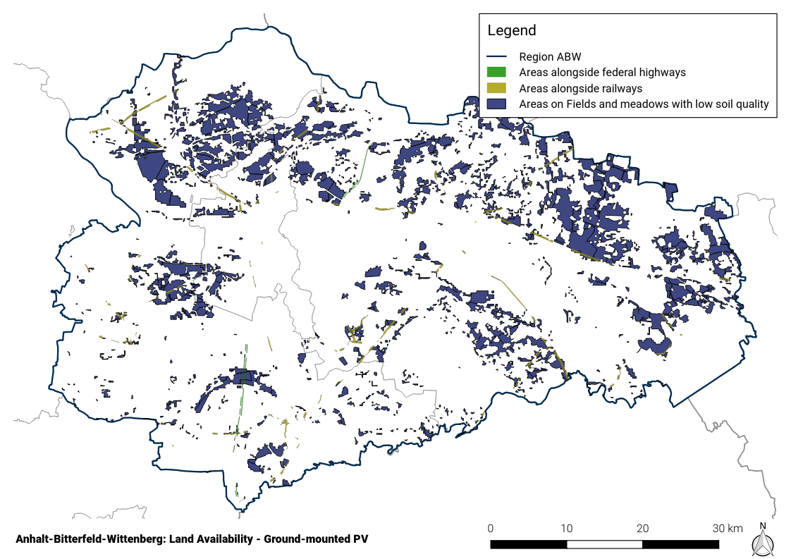
Ground-mounted photovoltaics ¶
Ground-mounted photovoltaic systems, with an installed capacity of 445 MW and a share of around 18 % of the region’s electricity demand, were already making a substantial contribution by the end of 2017. Further expansion is an important component on the way to a completely renewable energy supply, which must be carried out in consideration of their spatial and environmental impact.
The underlying methodology is presented in Fig. 8 : following the support scheme for ground-mounted PV according to §37 EEG (2017) potential areas are determined. Along the lines to determine eligible areas for wind energy as presented above, restrictive areas of different relevance are subtracted to gain the final eligible areas.
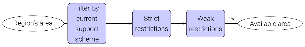
Fig. 8 Calculation of eligible areas for ground-mounted PV ¶
Potential areas ¶
The following potential areas are considered:
- 110 m strips along federal highways and railway tracks
-
A 110 m buffer zone along federal highways and railway tracks, less a 40 m zone around federal highways (§9 FStrG) and 10 m zone for railway tracks [87] is used. A width of 24 m (federal highways) and 12 m (railroads) is assumed.
- Soils with low arable yield potential (soil quality)
-
Large land potentials can be found in the agricultural areas. Following [88] , areas with low arable yield potential (soil quality) are used. For this purpose, the arable land and meadows from Corine Land Cover [89] are intersected with the areas of very and extremely low soil quality (<50) according to the Soil Quality Rating of the Federal Institute for Geosciences and Natural Resources [90] .
In the current planning, according to the climate and energy concept of the state of Saxony-Anhalt [77] , “the construction of ground-mounted photovoltaic systems on agricultural land should be avoided as far as possible”. In order to take this limitation into account, according to [88] only 0.5..1.0 % are assumed to be available as “spatially compatible” (German: raumverträglich verfügbar).
Other sites included in the EEG’s subsidy scheme - conversion areas (German: Konversionsflächen) and federally owned properties - are neglected due to their comparatively low potential and insufficient data availability.
Restriction areas ¶
The potential areas are opposed by restriction areas in which the construction of photovoltaic plants is excluded (strict restrictions) or unlikely (weak restrictions). Both the current legal situation and planning criteria are taken into account following the methodology of [82] .
- “Strict” restrictions
-
-
Settlements (+100 m buffer)
-
- Existing infrastructure
-
-
Federal highways (24 m width, +40 m buffer)
-
Federal, state and municipal roads (+20 m buffer)
-
Railway tracks (12 m width, +10 m buffer)
-
-
Railway properties
-
Airports and airfields
-
Standing water bodies and rivers (+20 m buffer)
-
Forest (+100 m buffer)
-
Nature conservation areas
-
Biosphere reserves
-
Floodplains
-
Natural monuments (German: Flächennaturdenkmale)
-
Drinking water protection areas: zones I+II
-
- Further restrictions imposed by the Regional development plan [80] :
-
-
Priority and reserved areas for agriculture (German: Vorrang- und Vorbehaltsgebiete für die Landwirtschaft)
-
Priority and reserved areas for raw materials production (German: Vorrang- und Vorbehaltsgebiete für die Rohstoffgewinnung)
-
Industrial and commercial areas of special significance to the state (existing + planned)
-
Industrial and commercial areas of special significance to the region (existing + planned)
-
-
- “Weak” restrictions
-
-
Fauna flora habitats
-
Special protection areas (SPA)
-
Landscape protection areas
-
Reserved areas for the development of an ecological network system (German: Vorbehaltsgebiete für den Aufbau eines ökölogischen Verbundsystems)
-
Priority areas for forestry
-
Nature parks
-
Priority areas for nature and natural scenery (German: Vorranggebiete für Natur und Landschaft)
-
Priority areas for water extraction (German: Vorranggebiete für die Wassergewinnung)
-
Priority areas for tourism and recreation
-
UNESCO heritage sites (in ABW: Gartenreich Dessau-Wörlitz )
-
Priority areas for agriculture (German: Vorranggebiete für die Landwirtschaft)
-
Further assumptions ¶
-
For economic reasons only areas >1 hectare are considered,
-
Existing plants and thus used areas are neglected.
-
For the specific space requirement, 1.5 hectares per installed megawatt peak (MWp) are assumed. Common values range from 1.5 ha/MWp [88] to 2.5 ha/MWp [84] . Due to efficiency improvements, among other factors, a lower space requirement can be assumed in the future (0.8 ha/MWp in 2030 according to [88] ). For the 2035 scenarios a value of 1.0 ha/MWp and for 2050 0.8 ha/MWp is estimated.
-
As described above, only a portion of fields and meadows are assumed to be “spatially compatible” [88] . Therefore, an upper threshold of 1.0% is assumed here. Date from CLC [89] shows that the total area of arable land and meadows in ABW is 208,578 ha, the maximum available potential area is therefore limited to 2086 ha (marked with (A) in the result table below).
-
Mutual overlaps of potential areas are minimal and therefore neglected.
Results ¶
After clipping the potential with the restrictive areas, eligible areas are determined. They are evaluated on two levels of restrictions: strict restrictions only and strict+weak restrictions:
|
Strict restrictions |
Strict + weak restrictions |
|||
|---|---|---|---|---|
|
Area [ha] |
Installable nom. power [MWp] |
Area [ha] |
Installable nom. power [MWp] |
|
|
Federal highways |
226,0 |
150,7 |
138,0 |
92,0 |
|
Railroad tracks |
1959,0 |
1306,0 |
963,0 |
642,0 |
|
Arable land, meadows |
45352,0 |
30234,7 |
13997,0 |
9331,3 |
|
Sum |
47537,0 |
15098,0 |
||
|
Federal highways |
226,0 |
150,7 |
138,0 |
92,0 |
|
Railroad tracks |
1959,0 |
1306,0 |
963,0 |
642,0 |
|
Arable land, meadows |
2086,0 |
1390,7 |
2086,0 |
1390,7 |
|
Sum incl. (A)* |
4271,0 |
2847,4 |
3187,0 |
2124,7 |
* The maximum available potential area is limited to 2086 ha, cf. Further assumptions .
An analysis of the results is given at the end of this chapter: Definition of land use scenarios .
Rooftop photovoltaics ¶
For roof-mounted PV, a dataset on the roof areas of residential and industrial buildings was provided by the Fraunhofer IEE [91] . The data was created in the herkules project using building footprints from [92] and [93] . The available space on residential buildings is estimated with 25 % and 50 % industrial buildings. Moreover, a specific space requirement of 7 m²/kWp is assumed for status quo, 5.5 m²/kWp for 2035 and 4.5 m²/kWp for 2050 using the reduction factor calculated from values of ground-mounted PV (cf. Further assumptions ). This results in a total PV rooftop potential for
-
Status quo (2017) (7 m²/kWp):, residential: 89 MWp, industrial: 795 MWp
-
NEP 2035 (5.5 m²/kWp):, residential: 113 MWp, industrial: 1012 MWp
-
ISE 2035 (4.5 m²/kWp):, residential: 138 MWp, industrial: 1236 MWp
Definition of land use scenarios ¶
Based upon the above potentials four different RE scenarios are defined: RE- , RE , RE+ and RE++ which reflect different land use configurations and accordingly, different degrees of RE penetration. Each of the global Scenarios is assigned one of these RE scenarios, a full list is given in Renewable energy installations (RE) .
The analysis of the available area for wind and PV installations already reveals important insights regarding the initial research question. Fig. 9 presents installable capacity of wind and PV for the four land use scenarios ( Wind+ and PV+ are integrated into RE+ ) and for each target year.
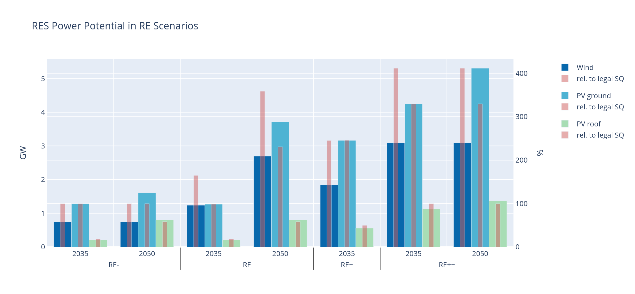
Fig. 9 Installable capacity for wind and PV considering four land use scenarios. Capacity is given in GW (wide bars, left axis) and relative to the installable capacity under consideration of the current legal status quo (narrow bars, right axis), which is applied to determine the capacity for RE- scenarios. ¶
On the left hand side, the scenario assuming the lowest capacity installations ( RE- reflects the current regulatory status quo. In this comparatively restrictive scenario, the available area for wind turbines and ground-mounted PV is entirely used and serves as a reference for the relative land use in the other scenarios. For realizing wind turbine capacity as assumed in RE (reflects capacity of NEP 2035 ), 165 % of the available area under current legislation would be required. This could already be achieved by wind installations in 10 % of not restricted forestal areas. In order to achieve installations according to ISE 2050 , it would be necessary to reduce the minimum required distance of wind turbines from settlements to 500 m. It further becomes clear, that in RE , there is sufficient space to realize the required ground-mounted PV power of NEP 2035 but not for the targets of ISE 2050 where the available area is exceeded by 130 %. For the more ambitious land use restriction scenarios RE+ and RE++ , the areas necessary for wind and ground-mounted PV strongly exceed the designated areas in 2035 as well as in 2050. In all land use scenarios, the capacity of roof-mounted PV is lower than or equal to the available potential. To sum up, it can be said that even in the regulatory status quo, the region has space to increase the amount of renewables to a certain extent, but to reach a deep decarbonization, the designation of further areas is essential.
Note
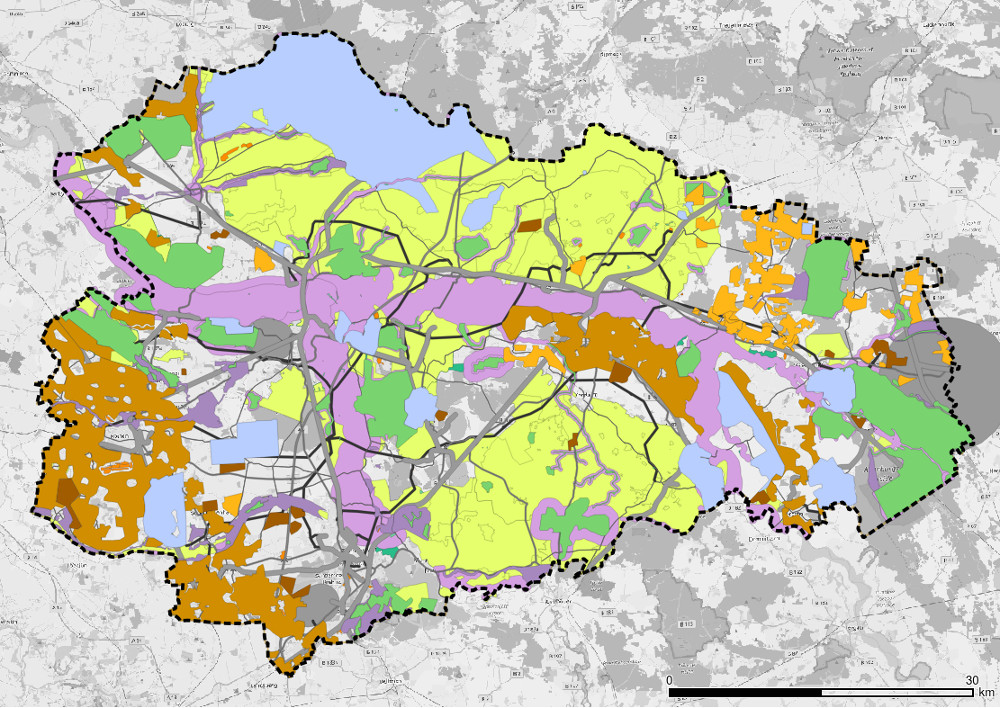
Further (geo)plots on potential areas on a municipal level can be found in the Results chapter.
Note
A detailed description on how the feedin timeseries of fluctuating renewables are calculated and integrated into the energy system model can be found in Fluctuating renewables .